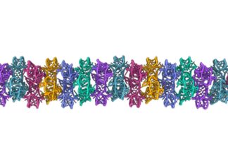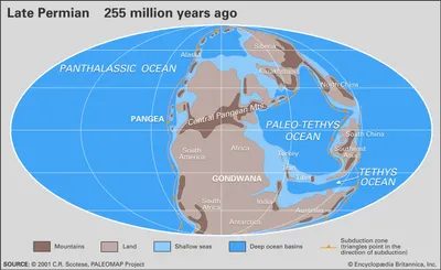
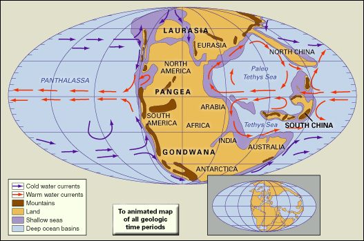
This is not always the case. The Continents we know today did not start as isolated islands in space. They were once chained together into a huge continent that covered almost the entire globe. Geologists call it Pangea.
The word comes from the Greek word pangaia which literally means “the whole earth”. This is a simple explanation of a complex reality. For a brief moment in geologic history, almost the entire earth as we know it was stitched together. Surrounding this supercontinent is an endless ocean called Panthalassa. This is a world without coastlines as we understand them. This is a world made of chunks of earth floating in a big blue soup.
Alfred Wegener didn’t find it by digging. He proposed this in 1912. A German meteorologist looked at a map and noticed something strange. The coasts of South America and Africa look like torn pieces of a puzzle. He called his idea continental drift. People laughed at him. He doesn’t have the skills to prove it. But he’s right. Pangea is more than just a theory. This is the starting point for understanding the movement of our planet.
Create a monster clash
The emergence of supercontinent was no accident. This requires a collision. It takes billions of years for tectonic plates to collide.
During the Devonian period, about 419 million years ago, the work was well underway. Two large continents were merging. Laurentia was the center of what is now North America, and the Baltica was the center of Eastern Europe. they are not alone. They dragged and pushed small bits of land and microcontinents. As a result, a new and large continent appeared, called Euramerica.
This is not the final format. This is just the beginning.
The real hard work happened in the Permian. It’s time for the supercontinent to fully join together. Think of this as a slow-motion car crash that takes millions of years. The northwestern tip of Gondwana eventually split into South America, India, Africa, Australia, and Antarctica and collided with southern part of Euramerica.
It’s not just a crash. It was an impact that shaped the face of the earth. Mountains appeared where there were no mountains before. Oceans closed up.
And then comes the last part. The Angara Craton is the ancient core of Siberia, slammed into the Euro-American-Gondwana fusion. This happened during the Early Permian period, about 299-273 million years ago. The puzzle is complete. Pangea existed as a fully formed supercontinent.
Why it matters now
Why do we care about a 300 million year old rock pile? Because it explains where we live today.
Breaking up Pangea was more than just moving dirt. It changes the climate. It’s a changed the oceans. The atmosphere is changing. When all the land mass was concentrated in one place, the interior parts of the continents were isolated from the moderating influence of the oceans. You get extreme deserts. You get harsh seasons.
When Pangea broke apart
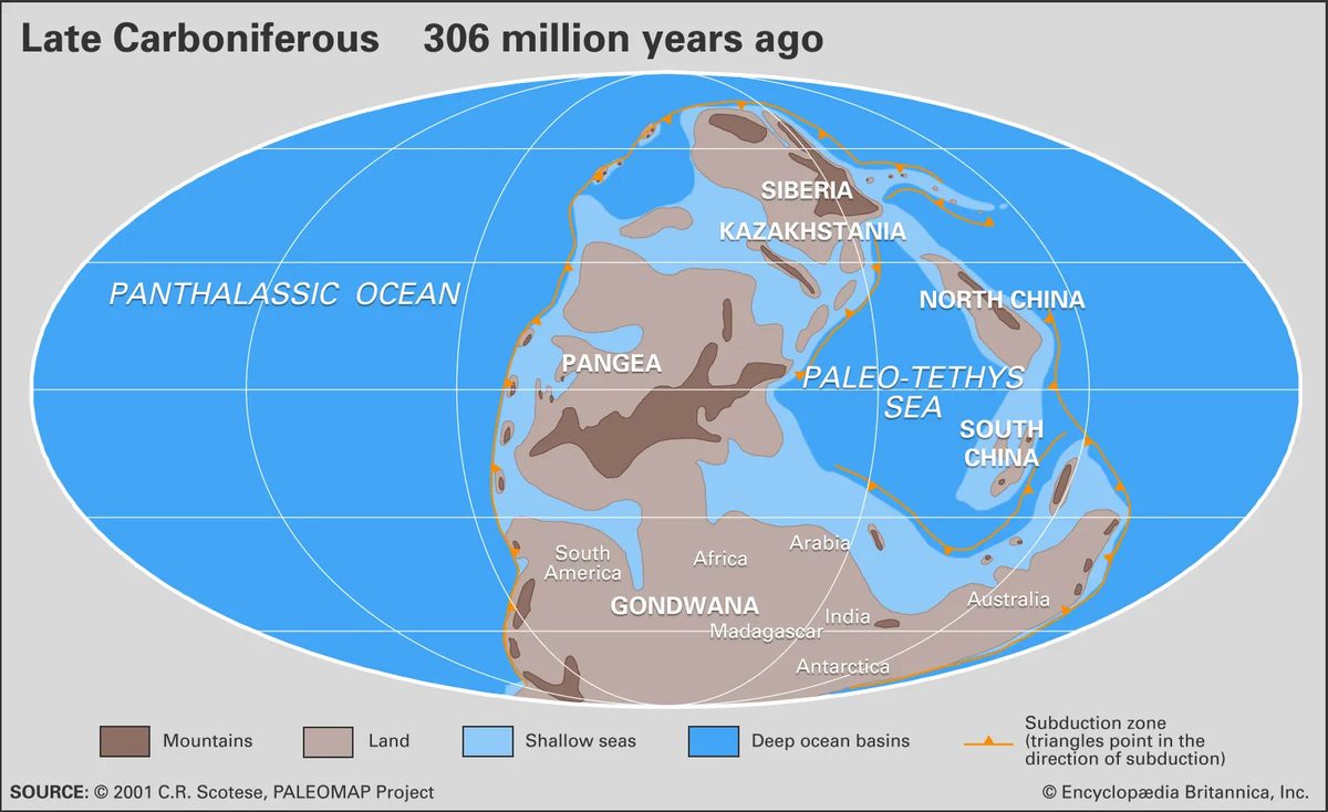
When most people think of Pangea, they imagine a solid piece, but in reality it was not round. It was C-shaped. Most of the mass is distributed between the Earth’s north and south poles. This curvature is important. More precisely, at its eastern end there is a huge gulf called Tethys Sea or Tethys Ocean. This is more than just a pool. It has shaped the history of Earth’s climate and tectonic movements.
The rise and fall of the ancient Tethys sea
The Paleo-Tethys Ocean formed during the initial assembly of Pangea. Think of this as the first big chapter in the story of this supercontinent. It has been around for hundreds of millions of years. But plate tectonics is rarely static. Something has to give.
It is a strip of continental material. Geologists call it the Cimmerian Continent or the Cimmerian Superterrane. It is detached from northern Gondwana. Then it rotated northward. This move didn’t happen overnight. It’s a slow, grinding shift.
Neo-Tethys Ocean replaces Old Ocean
As the Cimmerian block moved, it displaced the Paleo-Tethys Ocean. The Old Ocean was slowly replaced by the Neo-Tethys Ocean. This is more than just a name change. This is a fundamental change in geography.
Why is this important today? Because those ancient oceans controlled the movement of heat around the Earth. They influence where life flourishes. They determine the flow of currents. The collision of Cimmeria also laid the foundation for the future mountain building. The Alps and the Himalayas were born from this dance.
The Cimmerian superterrane separated from northern Gondwana and rolled north, closing the Paleo-Tethys Ocean and opening the Neo-Tethys Ocean.
It is easy to forget that the landmasses don’t stay put. They drift. they collide. They break. The Tethys Sea is a living, breathing part of this process. It is not static. It has evolved. In the process, it helped build the world as we know it.
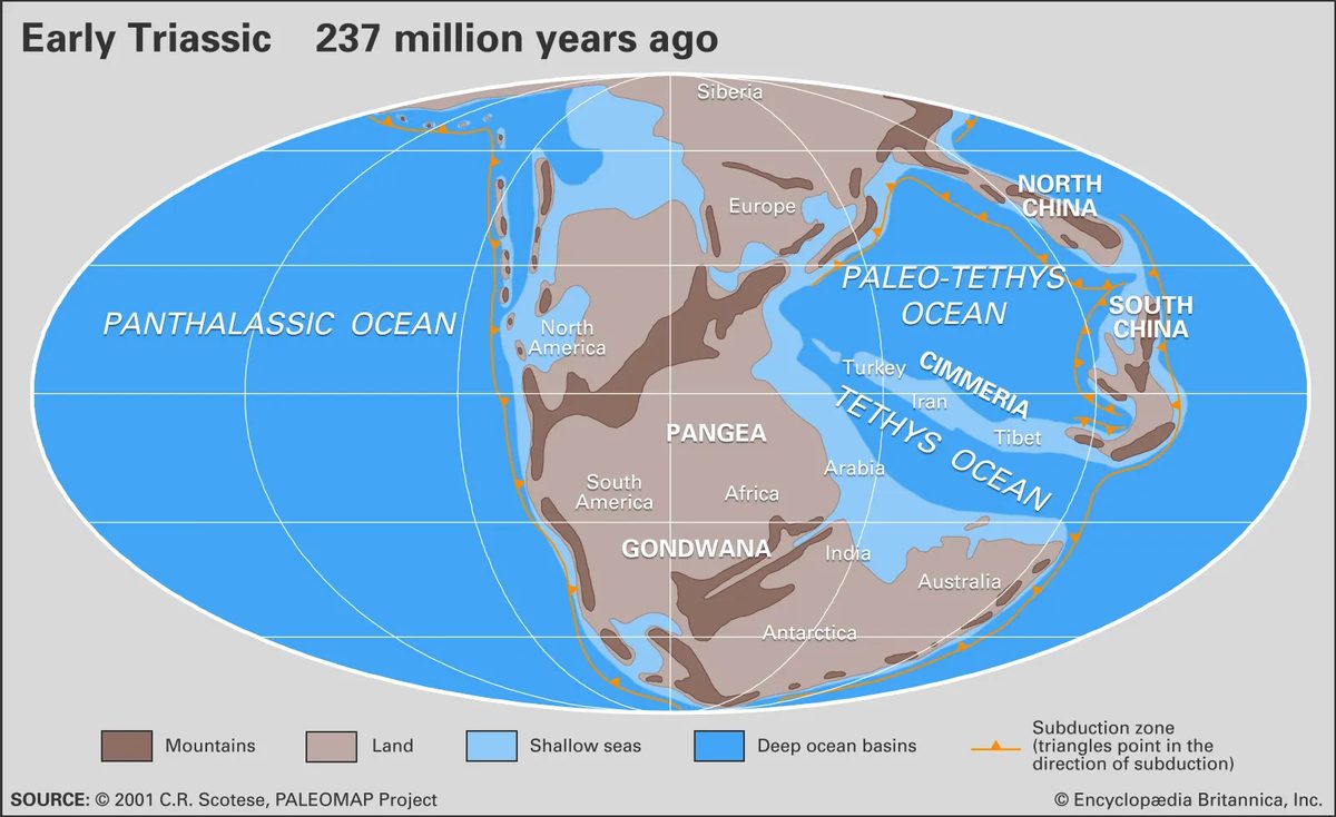
Although Pangea dominates geological discussions, its boundaries tell a more complex story. At the far end is Cathaysia, a unique continent often overlooked by larger players. It’s not just a stone. It was a huge extension of the eastern continent of Angara, uniting the regions known today as North and South Cathaysia into a single entity.
Where Cathaysia lives
Geographically, Cathaysia has a strategic position. To the west it lies on the vast Panthalassic Ocean, and to the east it competes with the Paleo-Tethys Ocean. These are not empty waters. They are dynamic environments full of geological debris.
Fragments of continental crust are scattered across two oceans and are called microcontinents. A basaltic volcanic island arc rises from the depths. Oceanic plateaus form huge underwater mountain ranges. Deep grooves carved into the sea floor mark places where tectonic plates collide or dive under each other.
How Terranes Formed
The oceans were not static. They were construction zones. Island arcs and individual land masses did not remain unchanged. Over millions of years, tectonic movements pushed them to the edge of Pangea.
Although these pieces collide, they do not sink. they are stuck. This process, known as accretion, welds this scattered debris onto the main continents. As a result, accreted terranes are formed. This is a unique continent that merges with existing continents and grows in size and complexity.
“These island arcs and other isolated land masses were later welded to the edges of Pangea, forming accreted terranes.”
Why is it important?
Understanding Cathaysia and these accreted terranes will change the way we see the supercontinents assembly. Pangea was more than just a spherical rock. It is a patchwork stitched together by the collision of microcontinents, volcanic arcs and oceanic plateaus. Cathaysia itself played a central role in this geological puzzle that connected the Asian continent to the tectonic structure of the world.
These ancient oceans are still clearly visible. The geological formations of Cathaysia and its surrounding areas bear the scars of these collisions. They remind us that the Continents are not fixed. they grow. They break. They accrete.
Climate change and the end of an era
When the continents collided to form Pangea, the climate didn’t just change; it broke. The tropical center of supercontinent became a vast dry wasteland. Why? This is because the low-latitude shipping lanes where warm surface currents travel freely have suddenly closed. The heat is shoved toward the poles. At the same time, cold water rose along the west coast of Pangea, unlike its burnt interior.
It’s not just a water problem. The collision of landmasses triggered a large-scale mountain-building activity called an orogenies. These new, steep mountains are not just there. They determine weather patterns. Two giant chains disrupt the flow of air from east to west in the temperate zone. One of them moves from east to west in the tropics. The second is the north-south intersection. Together, they divert warm ocean air away from the equator and push it towards higher latitudes.
This tectonic movement may have been involved in the mass extinction event that wiped out most of life at the end of the Permian. Paleoecologists believe the collisions destroyed a shallow ocean basin, the primary habitat for most marine invertebrates. The north-south orientation of Pangea also fundamentally changed the circulation of the oceans, changing the region’s climate in unpredictable ways.
By the end of the Permian, Pangea acted as a barrier. This prevented cold polar waters from flowing into the Paleo and Neo-Tethys basins. Without this cooling effect, shallow water temperatures would rise beyond the tolerance limits of corals and countless other organisms. The stage was set for a collapse.
Breakup
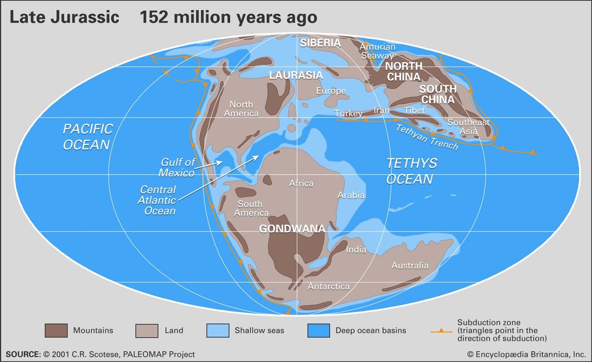
Alfred Wegener was almost right. He proposed that Earth’s continents were once stitched together into a supercontinent called Pangea, which dominated geologic time for a long time. But what about his explanation for how they broke up? It is fundamentally flawed. He calls it the “continental drift,” a concept that simply explains the “what” without explaining the “how.” Science has advanced. Today, we understand breakup through the strict lens of plate tectonics.
Movement mechanism
Wegener’s ideas lacked traction. Plate tectonics offers one approach. According to this theory, the Earth’s outer crust, the lithosphere, is not a solid, monolithic sphere. It is divided into large, hard slabs. These plates don’t just ride around aimlessly. They show different mechanical behavior depending on their location.
At the mid-ocean ridges, the plates move apart. Magma rises to fill the opening and forms a new sea floor. In a subduction zone, plates collide and one plate slides under the other. Along the faults, they slide and grind against each other, releasing seismic energy. This is not easy driving. It is a complex system of push, pull and friction.
Fragmentation is not immediate
One of the most common misconceptions about Pangea is that it was broken. Something like a dropped saucer. In fact, the difference is a series of different stages. The seafloor spreading patterns preserved in the magnetic stripes of the oceanic crust tell a different story. Superman didn’t disintegrate all at once. It was dismantled in a certain order over millions of years.
First, the Atlantic Ocean began to open, splitting North America from Eurasia and Africa. Later, South America became independent from Africa. After that, the Indian plate started its journey towards the north. Every step leaves a geological imprint. There are records of these separations on the seafloor, indicating that fragmentation was episodic, not catastrophic.
Loops instead of one-time events
Plate tectonics also suggests that Pangea was not the first supercontinent. This will not be the last either. Geological records show that Earth’s continents have merged and broken apart many times throughout history. This cyclic nature is driven by the same forces that split Pangea. Convection currents within the Earth’s mantle drive the plates. Sometimes they come together. Sometimes they diverge.
This raises practical questions for those interested in geology and resource distribution, including: * What specific fault lines define the present-day boundaries of the remaining supercontinent fragments? * The answer can be found in delimiting the edges of plate margins. Understanding this can help predict seismic activity and identify mineral deposits. It turns abstract geology into something concrete.
The important thing is that plate tectonics is a dynamic system. We tell you not only where the continent is now, but also how we got there and where we are going next. Wegener saw the destination. We now understand the vehicle.
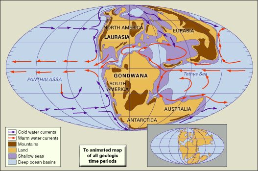
The story of our planet’s surface is not static. It was a violent slow motion collision.
Think of the Atlantic Ocean. The first major breakup occurred about 180 million years ago. The Mid-Atlantic begins to form between Northwest Africa and North America. At the same time, the southwest Indian Ocean opens up between Africa and Antarctica. These are not just cracks in the earth’s crust. They are the birth pangs of a new sea.
Then, about 140 million years ago, the South Atlantic was formed. Africa became independent from South America. It was an eventful separation. Around the same time, India began its long and lonely journey. It moves away from Antarctica and Australia to form the central part of the Indian Ocean.
Then came the Late Cretaceous turmoil. About 80 million years ago, everything changed again. North America became independent from Europe. Australia is starting to form its own crack in the icy continent far from Antarctica. Meanwhile, India cut the last rope against Madagascar.
This wasn’t just movement. This is a complete reconstruction of the world map.
Relevance to tectonic theory
Why is this important? Because these oceans are scars that show that the theory of plate tectonics is more than just a hypothesis. They are physical evidence of continental drift.
The timeline tells a concrete story about loneliness and reunion. India’s journey is the most obvious example. It didn’t stop even after leaving Madagascar. It surged northward.
This collision happened about 50 million years ago. India slammed into Eurasia.
The result? The Himalayas.
This is not a gentle merger. It was a bulldozer event. The crust buckled, folds and pushes upwards. Earth’s highest mountains are a direct result of a certain separation of the oceans and the subsequent land collision.
You can trace the contours of South America and Africa like pieces of a puzzle. If you look at the fossils on both sides of the Atlantic Ocean, you can see the same species. Oceans do more than just separate landmasses. They preserved the history of how they were once joined.
The Atlantic Ocean is younger than the Pacific Ocean, but older than the Caribbean Sea. The Indian Ocean holds the key to understanding the how the southern continents broke apart. This is a chain reaction. One crack leads to another.
Mountains are not the only thing that has been born from the collisions of India. It altered global climate patterns. It changed wind currents. It shaped the biosphere.
But the story doesn’t end there. Australia is still adrift. The Atlantic Ocean continues to expand. The planet is not done with us. We live on surfaces that are constantly recycled, broken and changed. The oceans we swim in today are only temporary containers for geologic process that has no end in sight.
The Birth of a Supercontinent
It starts with a map. Alfred Wegener didn’t need satellite data or deep-sea drilling to identify the fit. He saw a jagged edge in eastern South America and a corresponding curve in western Africa. They look like puzzle pieces torn apart by something violent.
Others had sketched similar ideas before him. But Wegener gave the concept a name and a timetable. In 1910, he began to formalize his ideas. He didn’t just guess the coastline; He was looking at the late Paleozoic Era. This period ended about 252 million years ago. It was a time of mass extinction. It was also the time when all present-day continents sat together as a single landmass.
He called it Pangea.
The name stuck because it represents the vast, unified Earth. Super continent. Wegener suggested that this giant mass wasn’t just sitting there. It broke apart. The pieces drifted to their current positions. This was a revolutionary idea in 1910. Most scientists thought the land was static. Wegener suggested it was mobile.
“The coastlines of eastern South America and western Africa are shredded like torn papers.”
Why is this important? Because it challenges the core belief that the Continents are fixed. If they move, everything else in the geology must change. Even if a fossil is found in one place, it means nothing if the earth does not move. But if Pangea existed? The fossil itself explains this. Animals could walk between what are now separate continents.
Wegner’s work was not perfect. He could not explain “how” the Continents moved. He lacked a mechanism. But he had a map. He had the intuition. It was enough to start a revolution. The supercontinent was real. The breakup was real. The only question is when and how.
How plate tectonics explains continental dgaps
Early geologists struggled to explain how Earth’s landmasses separated. Some suggested that large chunks of the supercontinent simply sank to form the Atlantic and Indian oceans. Alfred Wegener rejected this idea. He suggesteds that the pieces of Pangaea physically traveled thousands of miles over long periods of time. He called this process “die Verschiebung der Kontinente”. English speakers translated this as continental dgaps.
Wegener proposed this concept in 1912. However, he couldn’t convince the scientific community. The missing link were obvious. He had no working mechanism. How do the Continents move? What drives them?
Decades later, Alexander L. du Toit stepped in. South African geologist refined this hypothesis. He didn’t just see the supercontinent. He proposed two primordial continents. Laurasia is located in the north. Gondwana held the south. Du Toit gathered convincing evidence. Data supports movement. However, the engine that powers the dgaps remains a mystery.
This mystery was only solved in the 1960s. New theory has emerged. It replaced vague dgapsing with precise mechanical models. Scientists have developed plate tectonics. This framework finally explains the “why” of continental dgaps. It identified the rigid plates of the earth’s crust and the mantle convection currents that move them. The dgaps is real. Science needed proper language to explain it.
What is Pangaea?
Before the plates broke up, all the land were connected. This continent was called Pangaea. It existed during the late Paleozoic and early Mesozoic eras. Understanding Pangaea can help reconstruct Earth’s history.
The breakup of Pangaea did not happen all at once. This is a slow process. The forces of the Earth’s crust is due to tectonic pulled. New ocean basin created in the gaps. As North America and Eurasia drifted away from Africa, the Atlantic Ocean opened up. At the same time, the Indian plate surged northward and eventually collides with Asia. This collision created the Himalayas.
Without the mechanism of plate tectonics, these events would be mere coincidences. With it, they are an inevitable result of planetary dynamics. The earth’s surface is not static. It’s a moving puzzle.
Why continental dgapsing is important today
The transition from dgapsing to tectonics isn’t just academic. It changes our understanding of natural disasters. Plate tectonics explains why seismics happen. They occur at plate boundaries where tension builds up and is released. Volcanoes are created in places where plates separate or converge.
Knowing where these boundaries are will helps us prepare. This allows better tectonics codes in seismic zones. This helps geologists predict potential eruption sites. This theory turned earth science from a descriptive history to a predictive science.
Du Toit’s work kept the flame alive. Wegener’s initial vision provided the map. But plate tectonics provided the engine. Without that final piece, the story of the Earth’s surface would be incomplete. You notice that the ground has drifted. But we don’t know “how” it shaped the world today.
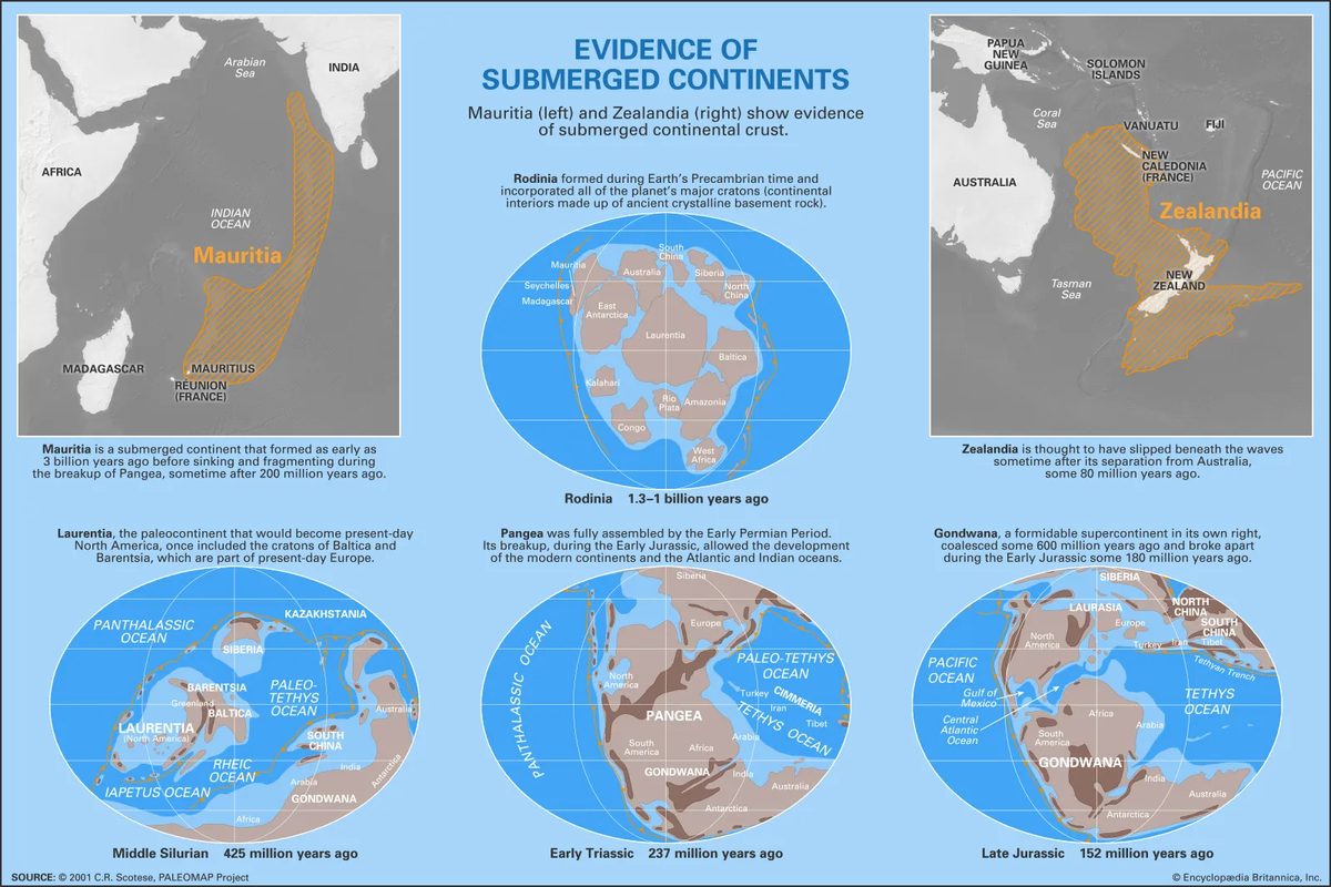
The story of the Earth’s continents does not begin with Pangea. It probably started long before we gave the Earth’s current structure a name. Geologists believe that we live in a recurring cycle where the Continents meet and break apart again and again.
The oldest of these known supercontinents is Rodiniaia. It was formed about a billion years ago during the Precambrian. About 600 million years ago, before Rodinia broke up, another giant continent called Pannotia merged. This also happened at the end of the Precambrian period. These are not static features. These are dynamic, violent plate collisions that shape Earth’s climate and life.
Which Continents Collide Today?
It’s not over yet. The same forces that once destroyed these ancient giants are now trying to unite them. Present-day plate motions begins a new assembly phase.
Look at Africa. It began to collide with southern Europe. The Mediterranean is shrinking, not expanding. At the same time, the Australian plate collides with Southeast Asia. These are not distant predictions. They are happening now.
Where will the next supercontinent form?
Periodic combinations of the world’s continents are called supercontinent cycles. Some call this the Wegener cycle, after Alfred Wegener, who first proposed the idea of continental drift. The current direction of development points to a future where Africa and Americas merge into Eurasia.
This new supercontinent is close to the proportions of Pangea. It will form over the next 250 million years. Details matter. The Atlantic Ocean may close. The Pacific Ocean expands or contracts according to the rate of subduction, which is not yet fully predictable. In the end, however, there will be one giant continent.
Why are supercontinent cycles important?
It’s not just about the rocks moving. Everything changes continents join. When the Continents merged, the interior of the supercontinent became a desert. Rain falls on the edges, not in the middle. Biodiversity is declining dramatically in the heart of heart of the land. Oxygen levels may decrease. Evolution slows down or changes direction completely.
Evidence of this can be found in the fossil record. Each breakup of a supercontinent was followed by a massive evolutionary explosion. Each stage of aggregation leads to extinction and stagnation. This cycle is the heartbeat of the earth.
How often does this happen?
Geologists have platesovered several supercontinents in the last billion years. Rodiniaia. Pannotia. Pangea. And now, we are heading toward the next one. This happens about every 300-600 million years. We are due for another collision.
It’s not a question of whether it will happen. This is the speed at which the plates moves. What will happen to living species when the ocean disappears and the world closes?
We live in the calm before the storm. The plates are already starting to move. We just can’t feel them.