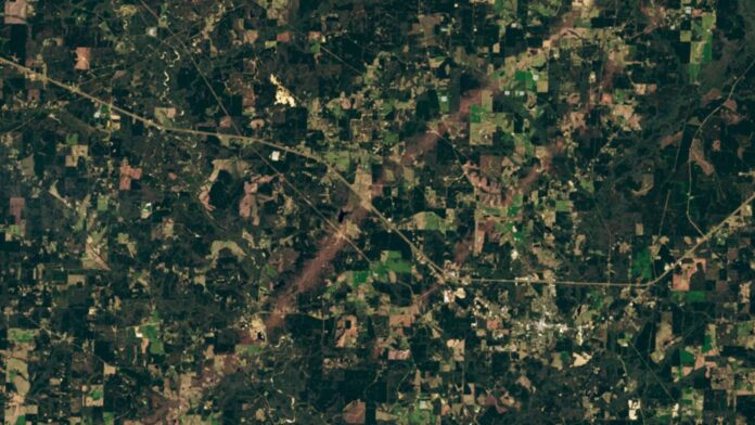
A striking satellite image captured by Landsat 8 on March 22, 2025, reveals the brutal aftermath of a powerful storm system that unleashed over 100 tornadoes across the U.S. The photo shows two near-perfectly parallel tracks carved into the landscape near Tylertown, Mississippi, a grim testament to the destructive power of nature.
The March 2025 Superstorm
Between March 14 and 16, an “expansive upper-level trough” of warm, moist air fueled a series of extreme thunderstorms in the High Plains and Midwest. The result was an unprecedented outbreak of tornadoes, with 113 confirmed twisters ripping through 14 states. Tragically, at least 42 lives were lost, according to preliminary reports from NBC News.
Mississippi was among the hardest hit, with 18 tornadoes reported. Half of these reached at least Level 2 (“considerable damage”) on the Enhanced Fujita scale, causing widespread destruction. The Mississippi Emergency Management Agency estimates that around 1,000 homes, along with numerous businesses and farms, sustained damage.
The Parallel Tracks
The satellite image focuses on two distinct tornado tracks just outside Tylertown. The longer track stretches approximately 55 miles (89 kilometers), while the shorter one spans about 9 miles (15 km). The sequence of events – which tornado struck first, and how much time elapsed between them – remains unclear.
The larger tornado is estimated to have reached Level 4 (“devastating damage”) on the EF Scale, making it the most powerful single twister of the entire outbreak. NASA’s Earth Observatory suggests wind speeds likely peaked around 170 mph (274 km/h), equivalent to a Category 5 hurricane.
Expanding Tornado Activity
The March 2025 event is part of a broader trend. This year has already seen record-breaking tornado activity, with 299 twisters reported in March alone – nearly four times the historical average of 80. The National Oceanic and Atmospheric Administration (NOAA) points to the recent La Niña phenomenon as a contributing factor, altering the jet stream and creating conditions favorable for severe weather in the southern U.S.
However, the increase in tornado frequency and intensity is also linked to long-term climate change. Rising sea surface temperatures, driven by human activity, are exacerbating extreme weather patterns, including tornadoes. As seen in 2023, single tornadoes can now reach unprecedented sizes and destructive power, claiming dozens of lives.
Moreover, tornadoes are increasingly impacting regions where they were once rare, suggesting a potential shift in “Tornado Alley” – the traditional high-risk zone. Some experts now believe that the area at risk may extend east of the Rocky Mountains, encompassing a wider swath of the U.S.
The convergence of short-term weather patterns and long-term climate trends suggests that extreme tornado events will continue to pose a significant threat to communities across the United States. Understanding these dynamics is critical for improving preparedness and mitigating the growing risks associated with severe weather.
